How geospatial solutions are transforming construction

Accurate and reliable measured surveys backed by industry expertise

Get a quote

Traditional surveying: reliable, but limited

Traditional surveying has been the backbone of land measurement for decades. Using tools like manual total stations, theodolites, optical levels, and tape measurements, these methods still hold value, especially for small, straightforward jobs. They’re proven, familiar, and reasonably precise.

But for complex, high-stakes projects, they present several drawbacks:

  • Labour intensive: Often requires multiple skilled operators
  • Time consuming: Slow data collection and post-processing
  • Inconsistent accuracy: Heavily reliant on human skill
  • Lack of integration: Difficult to connect with digital workflows or 3D models

In short, traditional methods may get the job done, but they’re not designed for the pace and complexity of modern projects.

What are advanced geospatial solutions?

At its core, a geospatial solution involves any technology or method that helps us understand the position of objects, features, or activities on the surface. In simpler terms, it’s about knowing where things are and how they relate to one another in space. Whether it’s mapping a construction site, analysing underground utilities, or modelling terrain in 3D, geospatial tools provide the spatial awareness needed to plan, build, and manage projects with precision.

Advanced geospatial solutions leverage technology to deliver faster, more accurate, and data-rich results. These methods not only reduce the need for large teams on-site but also produce outputs that integrate directly into digital project environments. As industries evolve through digital transformation, Red Laser remains at the forefront in driving innovation, enhancing efficiency, and reducing risk by placing location intelligence at the core of every project.

Tools and technologies that power advanced geospatial solutions

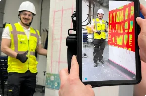
At the heart of advanced geospatial solutions is a suite of powerful tools and technologies designed to collect, analyse, and visualise spatial data with unprecedented accuracy and speed.

Robotic total stations

These automated instruments allow for single-operator surveying, eliminating the need for large field teams. With motorised targeting and automated data logging, they deliver pinpoint precision in positioning, making them ideal for tasks such as layout, monitoring, and topographic mapping.

Mobile mapping systems

Mounted on vehicles, these systems combine LiDAR, cameras, and GNSS to capture georeferenced, street-level data in motion. They’re perfect for surveying roadways, urban environments, and utility corridors, reducing field time and traffic disruptions while boosting data quality.

Drone (UAV) surveys

Unmanned Aerial Vehicles (UAVs) have revolutionised data collection for large, complex, or inaccessible areas. Equipped with high-resolution cameras and photogrammetry software, drones provide detailed aerial maps, 3D models, and orthophotos, rapidly and safely.

Ground penetrating radar (GPR)

GPR uses electromagnetic waves to image what lies beneath the surface, without the need to dig. It’s an essential tool for locating buried utilities, identifying voids or obstructions, and conducting structural assessments in concrete or pavement.

3D laser scanning (LiDAR)

LiDAR (Light Detection and Ranging) technology captures millions of measurements per second, generating high-density point clouds that accurately represent surfaces and structures. It’s especially valuable for capturing fine detail in buildings, infrastructure, and terrain, supporting everything from design to as-built documentation.

GIS (geographic information systems)

GIS is the analytical backbone of geospatial solutions, enabling users to visualise, query, and analyse spatial relationships. From environmental studies to asset management and urban planning, GIS provides dynamic maps and dashboards that inform smarter decisions.

Together, these technologies form a comprehensive toolkit that transforms how spatial data is gathered, interpreted, and applied, delivering deeper insights and greater efficiency for any project.

Geospatial solutions designed to meet the unique needs of every sector

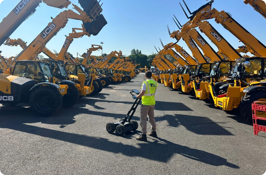
Advanced geospatial solutions aren’t one size fits all, they’re adaptable to meet the specific needs of various industries. In construction, they enable precise pre-construction planning and real-time progress tracking, reducing costly delays and rework. For utility providers, technologies like Ground Penetrating Radar (GPR) make it possible to detect and map underground assets without excavation.

In the transportation sector, mobile LiDAR systems capture accurate road corridor data quickly and safely, even in active traffic zones. Meanwhile, environmental professionals use GIS-based analysis to study terrain, monitor habitats, and support sustainable land management. No matter the sector, geospatial solutions bring clarity, efficiency, and confidence to the decision-making process.

Capturing detailed utility mapping data, our team provides comprehensive insights into underground utilities to support your project
Red Laser technician conducting a GPR survey to map underground assets without excavation, showcasing the power of geospatial solutions on industrial sites

Ready to build with confidence?

Red Laser’s advanced geospatial solutions deliver the accuracy and insight your project needs. Get in touch today to see how we can support your next construction or infrastructure project.

Contact us

Key benefits for your project

Choosing advanced geospatial solutions offers more than just modern technology, it delivers measurable improvements across every stage of your project. From planning to execution and ongoing asset management, the advantages are both immediate and long-term.

Speed

With technologies like drones, LiDAR, and robotic total stations, data that once took days or weeks to collect can now be captured in a matter of hours. This acceleration means faster site assessments, quicker decision-making, and the ability to keep critical project milestones on track, reducing costly delays.

Accuracy

Precision is paramount in construction and infrastructure. Automated, sensor-based tools significantly reduce the chance of human error, producing high-resolution datasets with millimetre-level accuracy. This ensures that designs, measurements, and installations align exactly with real-world conditions.

Efficiency

Advanced geospatial tools streamline workflows from field to finish. Smaller crews can handle more work using automated equipment, and digital data eliminates manual input and redundant processing. This results in faster project turnaround, reduced labour costs, and better use of resources.

Safety

Many projects involve working in dangerous or hard-to-access environments. By using remote data capture technologies, such as drones for aerial views or GPR for underground scans, teams can gather critical information without exposing personnel to unnecessary risk.

Integration

Modern projects rely on connected digital environments like BIM (Building Information Modelling) and CAD platforms. Advanced geospatial outputs are fully compatible with these systems, allowing seamless integration. This means faster handoffs between teams, improved collaboration, and a single source of truth throughout the project lifecycle.

Why it matters

With high-resolution 3D data, real-time processing, and industry-compliant workflows, advanced geospatial services are no longer optional, they’re essential. Whether it’s for infrastructure planning, site monitoring, or compliance documentation, the precision and flexibility offered can make or break a project’s success.

Partnering with experts: Red Laser’s advantage

When you choose Red Laser’s advanced geospatial solutions, you’re not just getting high-tech tools, you’re getting results you can trust.

Here’s what sets us apart:

  • Speed: Meet milestones faster with real-time data capture
  • Accuracy: ISO-certified workflows eliminate costly errors
  • Efficiency: Streamlined from field to finish with smaller, smarter teams
  • Confidence: Backed by decades of technical expertise and the latest technology

From robotic total stations to LiDAR, UAV surveys, and full BIM-ready outputs, Red Laser delivers the data you need to build smarter, safer, and more efficiently. We deliver more than just data, we provide clarity, speed, and confidence. Whether you’re overseeing a large-scale infrastructure project, tracking environmental changes, or optimising asset management, Red Laser’s geospatial solutions empower you to make informed decisions, minimise risk, and move ahead with certainty.

Take the next step

Get in touch with Red Laser today to schedule a scan or request a personalised consultation.

Get a quote

Have a