Measured Survey and LOD4 Digital Model - Fenchurch Street
Get a quote
Surveyor conducting measured building survey of a five-storey listed property in London
Location: Fenchurch Street, London
Project Overview
A detailed measured survey was commissioned for a five-storey listed building on Fenchurch Street, London, to support architectural analysis and heritage-led design development. The building features complex classical façades and decorative detailing, requiring a high level of geometric accuracy and modelling precision.
The client required reliable survey data to review the existing condition of the external envelope and inform future design decisions with confidence.
Client Requirements
The architect required:
Given the building’s listed status, the survey needed to capture fine architectural details—including cladding profiles, brickwork, doors, and decorative elements—without physical contact with the structure.

High-accuracy 3D laser scanning survey in London using calibrated FARO equipment to capture point cloud data for LOD4 digital modelling
Our Approach
Red Laser carried out a comprehensive colour laser scanning survey of the building, covering a gross internal area of approximately 6,000 m². Access to upper floors and roof levels allowed our team to capture high-level façade details and roof geometry that are often difficult to document accurately from ground level alone.
All data was captured using calibrated 3D laser scanners capable of recording up to one million points per second, achieving an accuracy of ±1 mm. The survey was delivered in line with the latest RICS professional guidance for measured surveys of land, buildings, and utilities.
Scan data was processed into a complete point cloud dataset, forming the basis for the production of accurate elevations and a detailed LOD4 digital model.
Deliverables
The final survey package included:
- Complete laser scanning measured survey
- External elevation drawings at 1:50 scale (RVT, DWG, and PDF formats)
- Fully detailed 3D LOD4 digital model
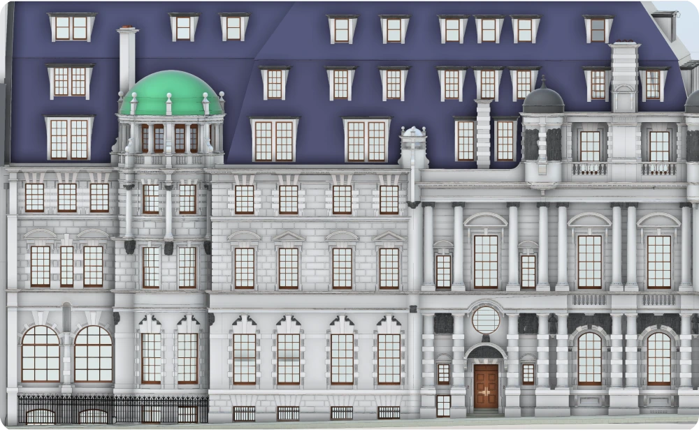
The LOD4 model accurately represents architectural elements such as façades, roof forms, and decorative features, providing a dependable digital reference for detailed design analysis.
Colour LOD4 BIM model of listed heritage building in London

Side view of colour LOD4 BIM model of listed heritage building in London

Roof view of colour LOD4 BIM model of listed heritage building in London

High-detail LOD4 Revit model showing classical stone façade and entrance

Accurate external elevation CAD drawing of listed building

Accurate side external elevation CAD drawing of listed building

Supporting Design and Analysis
The high level of detail captured within the LOD4 model enabled the client team to closely analyse the building’s historic fabric, including material transitions and façade articulation. The combination of precise geometry and visual clarity reduced uncertainty and supported informed design decisions at an early stage.
To improve collaboration and accessibility, survey data was also made available via Webshare Cloud, allowing project stakeholders to review scan positions, measure distances, and interrogate the survey remotely through a web browser.
Outcome
The measured survey and LOD4 digital model provided a robust, accurate representation of the existing building condition. By delivering verified data aligned with recognised industry standards, the survey reduced risk and provided the client with a reliable foundation for heritage-sensitive design development.
This project demonstrates how detailed laser scanning and high-level digital modelling support confident decision-making on complex, listed buildings.
Accurate LOD4 Revit model representing existing building condition, enabling confident decision-making for complex heritage projects
Start Your Project with Confidence
If your project requires accurate measured surveys or detailed digital models for complex or historic buildings, we can help.
Start working with us
Partner with Red Laser for a confident project launch